Project.Dream
New Member
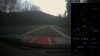
I finished my first rudimentary track which is based on a "Carrera 140 Profi", a german slot-car toy. Unfortunately I realized that the track is too small for faster cars so I will probably end this experiment. It was only made for learning to use the AC editor anyway so it is not a big setback for me.
I made a short video of me driving on the track, but the image quality is really bad because I had to use an external caputuring device.
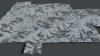
Next is a question about building real world tracks: The first thing I did to be able to model a road was to get a satellite image and a relief map. To define the height of the road on each point I thought about using the conturs of constant height from google maps or to use a greyscale relief map (I tried a generator from the city skylines community). Both of them seemed to be imprecise or hard to utilize.
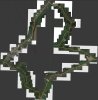
My idea then was to use the GPS device of a smartphone and to record the output while driving (see photos). I think the results looks promising - for the graphs I extracted one point every 2 seconds.
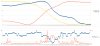
For this experiment I was driving about 2.5 km and had a height difference of about 147m. The upper graphs show the coordinates, the lower ones the error margins and the number of satellites that were available at the moment. I had hoped to also be able to extract the angle of the road surface (to precisely model steep corners), but the measurements were influenced by the g-forces while driving through a curve.
Do you think this could be a good method for getting more precise information about the track or is this nonsense?

I made a short video of me driving on the track, but the image quality is really bad because I had to use an external caputuring device.
Next is a question about building real world tracks: The first thing I did to be able to model a road was to get a satellite image and a relief map. To define the height of the road on each point I thought about using the conturs of constant height from google maps or to use a greyscale relief map (I tried a generator from the city skylines community). Both of them seemed to be imprecise or hard to utilize.
My idea then was to use the GPS device of a smartphone and to record the output while driving (see photos). I think the results looks promising - for the graphs I extracted one point every 2 seconds.
For this experiment I was driving about 2.5 km and had a height difference of about 147m. The upper graphs show the coordinates, the lower ones the error margins and the number of satellites that were available at the moment. I had hoped to also be able to extract the angle of the road surface (to precisely model steep corners), but the measurements were influenced by the g-forces while driving through a curve.
Do you think this could be a good method for getting more precise information about the track or is this nonsense?