So it seems my enthusiasm for LiDAR has been hampered by the fact that the data is not available. Short of contracting a company to scan the ground, what other options are there? I'm interested in making the track as accurate as possible so I can use it as a training tool.
There appear to be 3D scanners available that will probably take some time to scan a whole track as they produce measurements from a static location. For example, the Scanse has a maximum distance of 40 metres, which realistically means scanning every 20m and stitching the results together. However, it's accurate to 10mm, which is pretty reasonable!
There's the option of using elevation data and aerial photos in Google Maps, possibly improved by taking GPS measurements around the track to get more accurate elevation data.
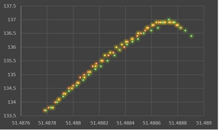
I could also build a kit that rolls along the floor and records GPS data for lat/long/elevation. Roll that down one side of the track and connect it via a cable to another unit on the other side of the track with a flat board. A range sensor would read the distance to the other side of the track and the cable would connect to an IMU (3D accelerometer and compass) that determines the angle of the cable, thus determining the camber at that point. That would allow the required data to be recorded around the track at every point; latitude, longitude, elevation, track width and camber. Is that good enough to give a realistic track map? Is GPS elevation data a high enough accuracy? Clearly, the absolute accuracy is not good enough, but the data I have of Castle Combe has a resolution of 0.1m and doesn't seem to drift much over a short period as overlaying the elevation over 3 laps of my GPS data seems to show very little difference. Here's 3 laps of longitude vs elevation up Avon Rise:
Photogrammetry is also possible, but in my experience, it needs lots of detail to work properly, so does it work well with grass/tarmac? There's some pretty simple tools out there that seem to work well with cities and other objects without big areas of single colours. I tried it out on my sports racer a few years ago and it was less than successful thanks to reflections and a big body of a single colour. Newspaper covering a car is hard work but feasible. The same cannot be said for a race track...
There appear to be 3D scanners available that will probably take some time to scan a whole track as they produce measurements from a static location. For example, the Scanse has a maximum distance of 40 metres, which realistically means scanning every 20m and stitching the results together. However, it's accurate to 10mm, which is pretty reasonable!
There's the option of using elevation data and aerial photos in Google Maps, possibly improved by taking GPS measurements around the track to get more accurate elevation data.
I could also build a kit that rolls along the floor and records GPS data for lat/long/elevation. Roll that down one side of the track and connect it via a cable to another unit on the other side of the track with a flat board. A range sensor would read the distance to the other side of the track and the cable would connect to an IMU (3D accelerometer and compass) that determines the angle of the cable, thus determining the camber at that point. That would allow the required data to be recorded around the track at every point; latitude, longitude, elevation, track width and camber. Is that good enough to give a realistic track map? Is GPS elevation data a high enough accuracy? Clearly, the absolute accuracy is not good enough, but the data I have of Castle Combe has a resolution of 0.1m and doesn't seem to drift much over a short period as overlaying the elevation over 3 laps of my GPS data seems to show very little difference. Here's 3 laps of longitude vs elevation up Avon Rise:
Photogrammetry is also possible, but in my experience, it needs lots of detail to work properly, so does it work well with grass/tarmac? There's some pretty simple tools out there that seem to work well with cities and other objects without big areas of single colours. I tried it out on my sports racer a few years ago and it was less than successful thanks to reflections and a big body of a single colour. Newspaper covering a car is hard work but feasible. The same cannot be said for a race track...
 .
.