barf
Member
Started my next LiDAR and ALOS/AW3D30 DSM based project, Mike Pero Motorsport Park, known more-affectionately by the locals as 'Ruapuna'.
There was already a Ruapuna on RaceDepartment but it's an old rFactor conversion and I think the scale is not accurate, plus it has some crazy bumps in the surface which are not really there (it's my local track and I can report the bumps do not exist).
About
The track surface is hot mix bitumen and runs for 3.33 kilometres (2.07 mi) in a counter-clockwise direction with many fast sweeping corners. It rewards smooth and tidy drivers.
The track also features a drag strip, pit garages, racing school, speedway circuit and even a radio controlled car circuit.
(Source: Wikipedia)
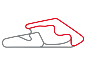
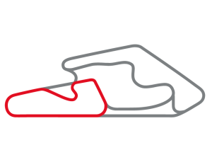
Map

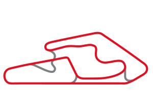
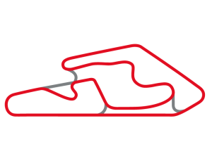
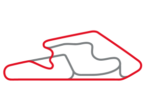
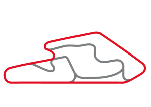
Layouts
It supports six layouts, from the 1.31km "A Track" to the 3.44km "Grand Prix with dipper".
Development
A scene origin was defined roughly in the center of Ruapuna at 1558000, 5180000 in the New Zealand Transverse Mercator (EPSG:2193) coordinate reference system. LiDAR DEM and ALOS DSM excerpts of the areas of interest were created using QGIS. BlenderGIS is used to import and generate faces from the point cloud raster (GeoTIFF) exported from QGIS.
The LiDAR DEM is textured with 0.075m/pixel orthophotos from Land Information New Zealand (LINZ). The ALOS DSM is textured with a 30m/pixel excerpt from the LINZ 'NZ Aerial Imagery' set pulled via WMTS in QGIS. The overall scene size is 1356 square km with some of the port hills and banks peninsula visible.
The above was done on a 7+ year old Chromebook running Ubuntu. So please think of the planet, and recycle your old computers with Linux instead of throwing them out")
Screenshots


Download
https://mega.nz/#!eOpw3QAK!Vp7qHYq4sYy6d2cGSejzLIo_EjjoAknuFN8kKN28Aps
There was already a Ruapuna on RaceDepartment but it's an old rFactor conversion and I think the scale is not accurate, plus it has some crazy bumps in the surface which are not really there (it's my local track and I can report the bumps do not exist).
About
The track surface is hot mix bitumen and runs for 3.33 kilometres (2.07 mi) in a counter-clockwise direction with many fast sweeping corners. It rewards smooth and tidy drivers.
The track also features a drag strip, pit garages, racing school, speedway circuit and even a radio controlled car circuit.
(Source: Wikipedia)
Map
Layouts
It supports six layouts, from the 1.31km "A Track" to the 3.44km "Grand Prix with dipper".
Development
A scene origin was defined roughly in the center of Ruapuna at 1558000, 5180000 in the New Zealand Transverse Mercator (EPSG:2193) coordinate reference system. LiDAR DEM and ALOS DSM excerpts of the areas of interest were created using QGIS. BlenderGIS is used to import and generate faces from the point cloud raster (GeoTIFF) exported from QGIS.
The LiDAR DEM is textured with 0.075m/pixel orthophotos from Land Information New Zealand (LINZ). The ALOS DSM is textured with a 30m/pixel excerpt from the LINZ 'NZ Aerial Imagery' set pulled via WMTS in QGIS. The overall scene size is 1356 square km with some of the port hills and banks peninsula visible.
The above was done on a 7+ year old Chromebook running Ubuntu. So please think of the planet, and recycle your old computers with Linux instead of throwing them out
Screenshots
Download
https://mega.nz/#!eOpw3QAK!Vp7qHYq4sYy6d2cGSejzLIo_EjjoAknuFN8kKN28Aps
Last edited:


