Les Neilson
Active Member
So I should export all the elements separately, then run them through kseditor one at a time?
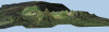
I've had this happen to me too, but I haven't found a way to fix it, unfortunately. I recommend you save your project regularly, and if this happens, quit out and replace the the current venue.bin file with a backup. What are you using to generate this?Good morning, what could be the reason that this happened to me from the attached photo?
I am using the latest stable version of RTB with IGN's WMS service following the manual from the first post with a local server mounted with the download of rtb_wms_inject_2017-11-15-zip (I don't know if there is a newer version)I've had this happen to me too, but I haven't found a way to fix it, unfortunately. I recommend you save your project regularly, and if this happens, quit out and replace the the current venue.bin file with a backup. What are you using to generate this?

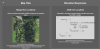
Thanks for your reply. Yes is DTM, you can download from here:Do you know if the data on the server is DTM (with trees etc. filtered out)? Can you download the data? If you can give me the url I'll take a look. You could also try my RTB plugin, but depending on the location it mayor may not work...
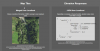
Thanks you @Les Neilson.I can have a look and maybe try the plugin. Can't promise anything, but if I can help I'll do my best. I see the data is in .asc format, which is a good start!
I'm sorry to bother you @Les Neilson , but could you try? Thank youI can have a look and maybe try the plugin. Can't promise anything, but if I can help I'll do my best. I see the data is in .asc format, which is a good start!
