DarkSession
New Member
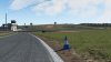
Well, i have a little problem. It's super easy to create a small track with RTB. But im strugglin to make a long track. The track should be around 28km long and 3km wide. The problem is, if i use RTB's in built features to catch the satellite data including elevation, everything is very low res and there is zero elevation, i guess this is because the poly count is very low. But even when adding geometry it doesn't change or just very little.
So im looking for a proper way to get elevation data from a big track, its not important for me to be super accurate, but there should be at least some sort of foundation to build from.
What i tried :
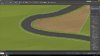
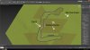
- Saving one high res image with SASPlanet and replacing the RTB background image with it. Struggled here to replace the image because im not sure how to save the exact same dimensions in SASPlanet as in RTB. My thought behind this is, that the low res picture can be replaced with a stitched together image from SASPlanet, but keeping the elevation data.
Help would be appreciated, thanks")
So im looking for a proper way to get elevation data from a big track, its not important for me to be super accurate, but there should be at least some sort of foundation to build from.
What i tried :
- Saving one high res image with SASPlanet and replacing the RTB background image with it. Struggled here to replace the image because im not sure how to save the exact same dimensions in SASPlanet as in RTB. My thought behind this is, that the low res picture can be replaced with a stitched together image from SASPlanet, but keeping the elevation data.
Help would be appreciated, thanks