Gunnar333
Well-Known Member
So here is my new track project. I will post some work in progress here to let you see how it develops.
For the terrain I will mostly use 3D data from Google which is from 2014.
For track layout (curbs, road lines, etc) I will use the Google 2D satellite map which is from 2018
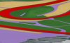
So you can see it's a similar approach than Prototype's Kyalami project but with 3DS Max.

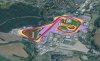
Google 3D Mesh with main track projected.
The circuit is located at the northern part of the Erzgebirge. It's a mountainious area. The main characteristic of the track is the many up and downhill sections which makes it fun to drive but on the other hand not easy to get it right.
next few weeks I'm on holiday so no much wip posts to come.
For the terrain I will mostly use 3D data from Google which is from 2014.
For track layout (curbs, road lines, etc) I will use the Google 2D satellite map which is from 2018
So you can see it's a similar approach than Prototype's Kyalami project but with 3DS Max.
Google 3D Mesh with main track projected.
The circuit is located at the northern part of the Erzgebirge. It's a mountainious area. The main characteristic of the track is the many up and downhill sections which makes it fun to drive but on the other hand not easy to get it right.
next few weeks I'm on holiday so no much wip posts to come.
")