Mitja Bonca
Active Member
In 3ds max must be a square, at least I had issues, as said. Estoril still has smallAs long as the scale is set to 1 it doesn't matter what the object is or what the size is. At least when using blender that is.
Kind of agree with Lilski here. It's not complicated, but in the first place it might be a good occasion to hit the wall first time, and actually understand what's with them@luchian
Do you think it is feasible to make available a standard set of pit/start/timer etc. objects for download and a discussion on how to best insert them? This seems to be hit-or-miss with me as I borrow from tracks and does not always work. Or is it just me. I understand (I think) how they work, but there are times they do not.
Cheers
Yes, you have a point. If you would go wide when entering a pit, you will get a penalty.You can adjust the size of the penalty area to compensate, but be aware some leagues will run less than the default 3 wheels. Also, wouldn't putting a cut area there mean that you'll get a penalty any time you enter the pits?
Hey @ArkSyve , welcome and nice to see you giving modding a try.Should I first get GEarth terrain data/point cloud data and somehow model a road arround it? In which case I'm stuck on how to place/fit/carve my road on that terrain properly.
Should I start with creating my road and then elevate it point per point using elevation data and afterwards model the terrain arround it? (kind of the hard&long way)
Is there another way I don't know of? Again, I'm new to blender so there's definitely stuff I'm missing out on.
Thanks for the help.Hey @ArkSyve , welcome and nice to see you giving modding a try.
Well, your listed options are not complementary or opposing each other.. They are merely different possibilities on how to do. But generally speaking the approach is:
1/ if you have access to data, GET IT. And here I mean lidar, plans or GE.
2/ in the case of plans and lidar (we have a tutorial about it), you can't use that for anything else than reference. So you'd use it as a guide to accurately position your track. Depending on the software you use, you can go different ways about this. But in Blender, one good solution is to build a bezier curve following the track layout and then use an array modifier with a piece of road and follow that curve.
EDIT: and here a useful advice from master lilski whn applying the above.
I have a problem. Take a look at this image:
![]()
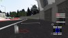
Its penultimate turn @Okayama. Is there any way to prevent cutting the curb (or even driving on the pit road, which this still is not, its just a driveway to pits)? Between road and access road to pits is only some curb (red, white).
How would I penalize someone, if he will drive on the red side, but not going to pits?
Its hard to define, who`s going to pits, and who is not.
I am afraid there is not much to do, I suppose. I tried to add additional sausage curb (on right side of this one), but cutting on the right side of it, is still possible, and it can cause some high jumps as well, if driving over it. No clue anymore what to do. Or should I leave as it is in reality (like you see on this image)?
Are you converting or making new?3DS Max guys, how are you subdividing your physical mesh? Gave it 0.4m and its super rough around corners... EDIT: have a subdivide of 0.7m, which kept the physical mesh at a decent triangle count. but still too smooth, how much noise do you guys add on the Z axis? like .01?
Pro-optimize, will give that a go!in max I subdivide and pro optimise numerous times to get to the physics level. always preserving borders where possible...