• Dear visitors,

    The email issue has been finally solved.
    Thank you for your patience and happy browsing.

    Team ACM.

W.I.P. Circuit Mont-Tremblant (St-Jovite) 1969

Patrice COte

Active Member
Since I finally have something nice to show, I’m extremely happy to announce my track project: Le Circuit Mont-Tremblant (St-Jovite) 1969 in Canada. It has been an obsession of mine to get this track done properly with the narrow, dangerous, and very bumpy original layout where nearly every corner is blind. I have been at it for years (on and off) collecting historical pictures (must be close to 1000!), videos, going to see races there and take reference pictures. After several unsuccessful attempts various software, I think this is finally the good one (got to learn 3D modelling the proper way with Blender). Getting to learn everything needed is complex and time consuming, but thanks to the forum resources here at ACM (and a lot of motivation!), I’m finally there.

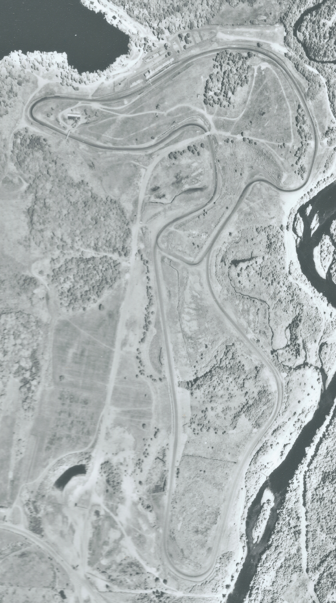
Getting (at last!) a high resolution aerial picture from the 70’ got me back at it this time (no lidar available yet, not until 2019 I’m told). Picture below is not full res ;-)

1975 aerien Circuit mont-tremblant Infrarouge - mini.png


Background information

The track was a huge success in 60’s and nearly every big series made a stop there. So just to name a few :

CanAm ‘66, ’67, ’69, ’70, ’71, ’77, .78

Formula 1 ‘68 and ‘70

SCCA Trans-Am, ’68, ’69, ’70, ’71, ’77, ‘78

F5000 ’69, ‘70

The late 60’s was really the golden era not only for the high profile races but also popularity. Every race weekend was one giant outdoors party with huge crowds. Hopefully I can bring back some of that feel to the simracing world.

The track phased out of top level racing in the 70’s due to very legitimate safety concerns, very bad condition of tarmac, oil crisis, inadequate pit area and the long distance from Montreal. The opening of the Ile Notre-Dame Circuit in fall of 1978 (to be renamed Gilles Villeneuve) was the final blow. However, the Circuit Mont-Tremblant maintained a high reputation amongst drivers who loved its tricky corners and wild elevation change. There was still a lot memorable racing in the 80’s with Porsche Cup and other national series, at which time (as a teen) it really caught my imagination.

The 2000-2001 rebuild by Laurence Stroll saved the track from demise and brought it back to modern standards. There were changes made, as little as possible, to make it a lot safer. They did an amazing job, still I can’t help thinking some of the wild and raw landscape got diluted along the way, I hope to recapture it with this virtual version.

This is my first track, please be patient, I'm aiming for quality here, it should be worth it.
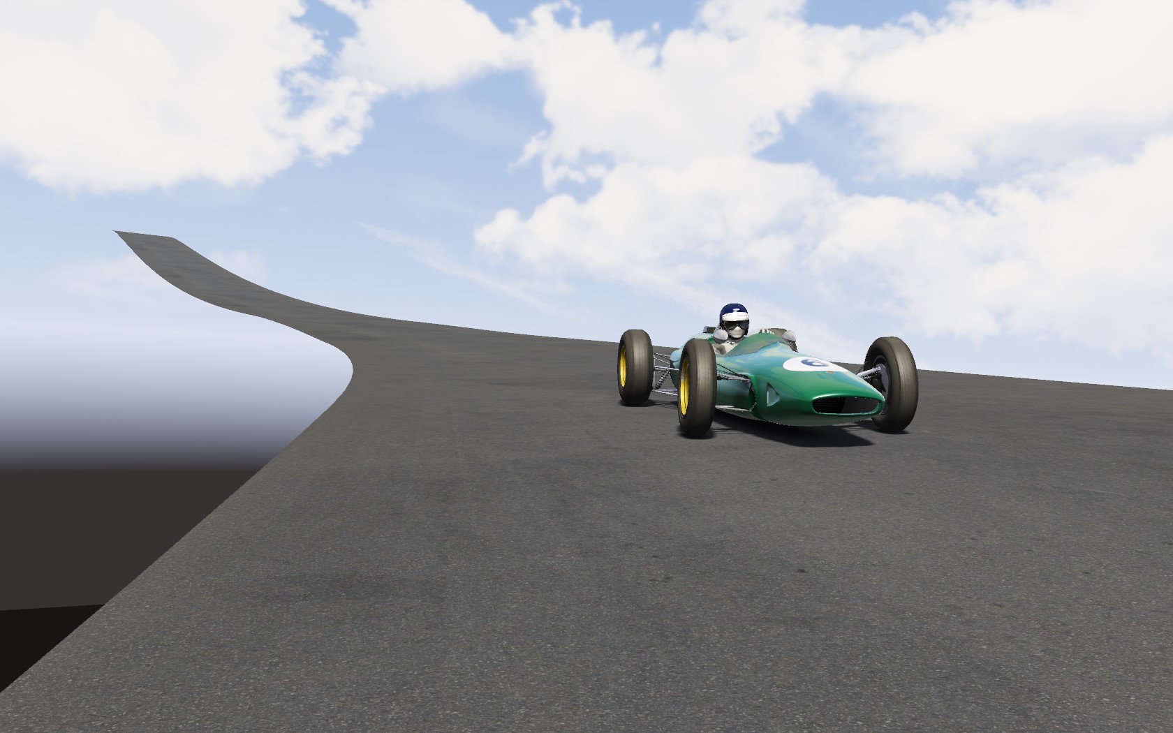
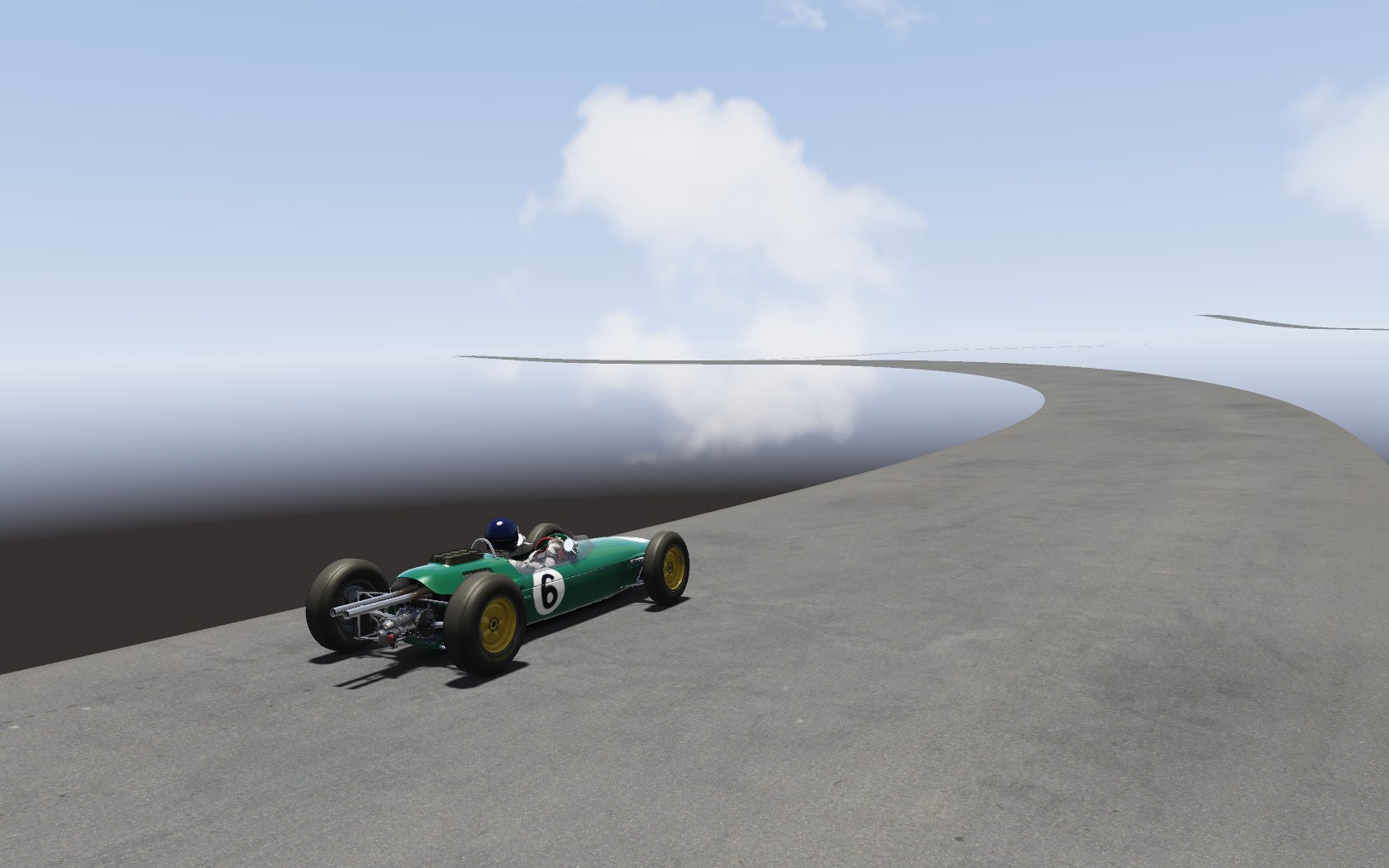
Here's a couple of shots of my first lap.

Screenshot_ks_lotus_25_mt-tremblant_69_11-2-118-23-35-11.jpg


Screenshot_ks_lotus_25_mt-tremblant_69_11-2-118-23-36-15.jpg
 

Johnr777

Moderator
Really cool project! :)

I did a quick google search and yeah, couldnt find lidar data for that region... I dont speak french, so my search was very limited...

How about GPS? if the track is still active, im sure someone would've posted a trackmate file or similar, or you could map it with your phone if you are in the region.
 

Patrice COte

Active Member
I have been in contact with the Natural Ressource Department and they plan to make a LIDAR scan in 2018 but the data will only be availble somewhere in 2019 (and will cost$$). Last year I had put this project on hold in hope the LIDAR would be available sooner. I got fed up with waiting, got to work and I don't regret it!
I'm surprised by the amount of detail that can be extracted from pictures (camber and elevation), it's very tedious but I feel I know every inch of the track now. I'm starting to have a feel of what's good or not even before I compare with the ref pictures.

I do have plenty of DEM models (3 different souce), so no worries for the surrounding hills they will be there, you should even be able to see the ski slopes in the distance.

I found a GPS recording, but the data is really bad, there's a 5m vertical offset after a lap. Much less accurate that DEM + eyeball.
 
Last edited:

luchian

Administrator
Staff member
Initially I thought the photo is a lidar render :). I don't know this track, never heard of it but the layout seems interesting. As I can see from your shots it also seem to have some very pronounced elevations. Eager to see more.
 

Patrice COte

Active Member
Yeah, it's a real roller coaster built on very steep terrain. Easily in the top 5 north american track (IMO, of course I'm biased!). There's a lot in common with the other amazing tracks built in the late 50's up to mid 60's such as Mosport, Bridgehampton, Westwood, Mid-Ohio. etc.. It has been compared to the Nordschleife by M.Schumacher (not sure he drove the old or the 'new' track).

Here's a couple of shots showing the mad elevations. Note that the Lola T70 spyders (canam '66) were taking off over the hump on the back straight causing accidents. Henri Pescarolo ( F1 race for Matra) said the cars were taking off at 2 places. It's a blast with any car and a proper driving challenge.

1970 - F1 HD.jpg

197x_T2-T3.jpg


1970 F1 virage 1.jpg


MT-Tremblant - 1977 2 .jpg

1968 namerrow_f1.png
1970_kink.jpg

1970 F1 GP 10 bout de la ligne droite.jpg
 

Anthony NR

New Member
I actually live in Mont-Tremblant, when I was a kid I was going there once a year with my father to see races (I still got ad-posters from 2002). I would love to play on this circuit, as I can't go on it yet, not until I get a race car or have enough money to rent one/take classes (I'm still a student...). If you need any help I'm a quick learner and would love to spend my spart time doing something like this.
Bonne continuation, j'espère voir ce projet aboutir un jour ! ;)
 

mantasisg

Active Member
I am very interested in this track, can't wait to see how it will go. Good luck with it :)

I see you have only road now, you could extrude edges for a grass, that would make it much easier to join it to the terrain in future, also it would allow you to easily shrinkwrap transitional tarmac-grass elements in future and save you lots of time. Eventually if LiDAR will be available one day, you should be able to rather easily addapt it to LiDAR, unless I can't think of something what could make it difficult now...

What an awesome circuit !
 

Patrice COte

Active Member
Don't worry, road edges transition mesh and grass already extruded all around (the offset edge addon for Blender is my best friend, along with un-subdvide ). Good to know it will be easy to retro fit the Lidar when available. The first images were "victory shots" from finally getting my first export to work in-game. It's really a satisfying feeling to drive your own track, I'm finally getting why it's kidda "worth" it to spend unhealthy amount of time to work on track mods.

I'm currently putting lots of time testing and adjusting so the road geometry is right (and having way too much fun.... ;)), down to tweaking a few complex spots. I'll have a lot more to show shortly, and certainly some questions about terrain texturing.
 
Last edited:

mantasisg

Active Member
I just wrote a big post in official AC forrums about terrain texturing/multilayerfresnel shader...

I might as well, improve that post later and post here. I think I have rather good understanding of that subject, though really haven't mastered it.
 

Patrice COte

Active Member
I just wrote a big post in official AC forrums about terrain texturing/multilayerfresnel shader...

I might as well, improve that post later and post here. I think I have rather good understanding of that subject, though really haven't mastered it.
That's really good stuff there, thanks that will be very useful.
 
Last edited:

Patrice COte

Active Member
Here are some progress shots.
Terrain and transition textures are place holders.

The bridge turn gave me lots of headaches. Re-did so many times. Then I built the bridge only to realize the elevation wasn't perfect due to field of view thru the arch.

Anyhow, things are moving forward, terrain is very rough at the moment but improving.

Top view in blender with background image
2018-03-18_top_view.JPG

Bridge
2018-03-11_bridge turn 2.JPG

Bridge corner exit

2018-03-11_bridge turn.JPG

Gulch corner
2018-03-11_bridge turn3.JPG


T1
T1.JPG


T14-15 and pit entry
T14-15.JPG


T3 -T4 (esses)
2018-03-18_esses.JPG
 

mantasisg

Active Member
I will try to share my knowledge. About terrain texturing. Thats a bit edited post of what I have posted in AC official forum a while ago.

I am no expert in the shaders, don't really know exactly what everything does, haven't studied the theory...

I am writing this from memory, so sorry for possible lies, and not totaly clear maybe

Bits about shaders:

MultRGBA scales up the RGBA detail textures, I don't really use A -Azure.
MagicMult is something like exposure.. I usually use it 0.5-1.0, depends on diffuse brightness, I guess.
FresnelC has an effect of shine in closer distance, I suppose it is like effect of sky reflection or something.
FresnelMaxLevel, I think is shine level depending in distance, or maybe I am mixing it up with fresnel EXP.
Tarmacspecularmult... Also controls shine level in further distance, I think
FresnelEXP - controls how the shine is fading down, I think
Specular settings are also important, especially specularityexp, as it has an effect on surfaces shine and color too.

txDiffuse is base texture, alpha channel controls specularity, but, I think, normal map alpha channel also does it.
Mask - to determine how details will be distributed. Alpha channel also does some tricks there, for example if you want some gravel/ground/sand bits to stand out (which would be red color in mask) you can do some adjustments with alpha channel too, I don't completely understand those alpha channels.
Normal map is normal map :lol:, I am using one large 4K NM map for my Nemuno Ziedas, it can help to add plenty of detail to terrain this way, but has cons too, also needs a lot of work to do it good. Usually it is tileable NM map, which is better for better low range detail, less difficult ro use, also with alpha channel allowing for nicer specularity effect, and ofcourse will take much less space, as 4K is HUGE.

You can easily make base image for terrain by asembling lots of Googleearth pro "renders" together, fitting them to 4K and adjusting image noise levels in photoshop. You can make diffuse by making it Black and White and adjusting brightness/contrast and more. Or you also can assemble them to 8K image, and later downscle, or not if you don't care :D

You can make a map image by boosting up the saturation very heavily of base image (of course while it still has color :lol:), and then adjusting it...

You can also do it all by painting stuff manually.

If you wouldn't use tileable NM, which is traditional way. You can make one huge NM image by using NM generators, there are lots of them available, some are free. Might need lots of adjustments and fine tuning after...

ONE MORE thing about using one huge NM map is that you have to UV map whole thing in correct places, otherwise there will be shading artifacts at certain times of the day. Unless something could be achieved to solve that by adjusting NM image color balance, as I have learned by fooling around with XJ13 body paint material NM image - as I was changing color of NM the shading of different "UV islands" was getting seriouasly messed up... Edit probably could be done by having UV islands as well, but then the colors should be very flatened, and i suppose that would be difficult to achieve. Anyway, everyone use tileable NM I think.

I used tileable NM in Goodwood, but one big NM in Nemuno Ziedas.

I am not an expert, just few things might help I hope. Sorry for messy post this time.
 

Patrice COte

Active Member
This project is not dead!
Here are some progress shots (in editor or in-game)
Really happing with the main pit building (I'm not telling how long it took to make!!!!!!!)

The terrain main diffuse is just a placeholder (modern layout shows thru), it looks OK from far away, but track level is not good at all. Will probably have to hand paint it all. The terrain topology is still giving me a hard time, but I'm getting there. I imported a fairly large 3D map to capture all the hills (and lakes!) in the area.

Enjoy!

Screenshot_ks_ferrari_250_gto_mt-tremblant_69_8-12-118-0-18-31.jpg

Screenshot_ks_ferrari_250_gto_mt-tremblant_69_8-12-118-0-19-19.jpg

Screenshot_ks_ferrari_330_p4_mt-tremblant_69_15-12-118-0-42-51.jpg

Screenshot_ks_ferrari_250_gto_mt-tremblant_69_8-12-118-0-21-49.jpg

Screenshot_ks_ferrari_330_p4_mt-tremblant_69_15-12-118-0-36-42.jpg

Screenshot_ks_ferrari_330_p4_mt-tremblant_69_15-12-118-0-38-58.jpg
 

mantasisg

Active Member
Can't see the last two screenshots.

Glad that you have progressed. Pit building looks quite decent ! As it is white a good Ambient Occlusion bake would improve it a lot.
 

luchian

Administrator
Staff member
For some reason, the screenshots do not load properly. Just refresh the page, they should appear :confused:

YES to the AO.
 

Patrice COte

Active Member
I know, the AO... it's on the list. No worries.

By the way, does anyone have a good normal map for water ripples (lake not ocean)? I've tried to make many from pictures without any good results.
 

Patrice COte

Active Member
Sorry for lack of news, had a very busy winter (I did find a quick fix for the water NM in december). Still I did find time to keep the track moving forward.

The biggest improvement is invisble, the road's physical mesh is pretty much final (after 15 iterations). Really bumpy (in a nice way I think) and lots of feel.
Made and AO baked a few secondary buildings
Re-organized textures the right way
Functionnal short layout
Added electric poles, tons of fences (still WIP) many more missing + a few rails.
Added concrete curbs.
Kept improving terrain, added proper mesh for the river too.
Manual knitting of road (curve) mesh with terrain
And learned tons of new techniques in Blender to make things the right way (moving along that learning curve). Re-did quite a few things...

Terrain texture are still totally placeholder as you can tell (no transition texture either - currently beige texture) I'll re-unwrap everything with RGB and details map. This is my next big learning step along with trees and grass.

I'll try to make a full lap video recording to show this thing in action.

Meanwhile, here are some pictures, enjoy!

Screenshot_ks_lotus_72d_mt-tremblant_69_14-5-119-0-12-31.jpg

Screenshot_ks_lotus_72d_mt-tremblant_69_14-5-119-0-9-53.jpg


Screenshot_ks_lotus_72d_mt-tremblant_69_14-5-119-0-8-35.jpg


Screenshot_ks_lotus_72d_mt-tremblant_69_14-5-119-0-7-34.jpg


Screenshot_ks_lotus_72d_mt-tremblant_69_14-5-119-0-11-8.jpg


Screenshot_ks_lotus_72d_mt-tremblant_69_14-5-119-0-10-37.jpg
 
Last edited:
Top