• Dear visitors,

    The email issue has been finally solved.
    Thank you for your patience and happy browsing.

    Team ACM.

W.I.P. Circuit Mont-Tremblant (St-Jovite) 1969

Patrice COte

Active Member
At last (!) here's a video of the track in its current state. There is still a lot to do in the eye candy department, but the look of the road, bridges, curbs, fences, rails is pretty much "final".


If you want to compare to the real thing (from the 1969 movie "The Racing Scene"):

Jump to 1:11 for on board track footage
 

Patrice COte

Active Member
Here are some news about Mont-Tremblant 1969.
I've been learning lots of new tricks, redoing things over and over, tweaking and it's finally starting to look a bit like what envisionned years ago.
A beta version of track as also been successfully tested a couple of days ago in a private league race with 67 F1, current DIP is around 1000 with max Grass FX enabled.
I'm still far from done with it.
I have to say CSP Grass FX is a real life saver. I customized the texture with some of the local plants (still WIP) but already looks awsome in my opinion.

Screenshot_gpl67_ferrari_312_mt-tremblant_69_18-2-120-21-40-7.jpg

Screenshot_gpl67_ferrari_312_mt-tremblant_69_18-2-120-21-39-8.jpg

Screenshot_gpl67_ferrari_312_mt-tremblant_69_10-3-120-23-2-55.jpg


Screenshot_gpl67_ferrari_312_mt-tremblant_69_10-3-120-23-1-0.jpg

Screenshot_gpl67_ferrari_312_mt-tremblant_69_4-3-120-0-5-3.jpg
 

Attachments

Johnr777

Moderator
Here are some news about Mont-Tremblant 1969.
I've been learning lots of new tricks, redoing things over and over, tweaking and it's finally starting to look a bit like what envisionned years ago.
A beta version of track as also been successfully tested a couple of days ago in a private league race with 67 F1, current DIP is around 1000 with max Grass FX enabled.
I'm still far from done with it.
I have to say CSP Grass FX is a real life saver. I customized the texture with some of the local plants (still WIP) but already looks awsome in my opinion.
Oh wow, what an awesome surprise! Looking real good, and seems like you have picked up all the track modding tricks.

On the one Ferrari shot, all the grass seems flattened, config issue?
 

Patrice COte

Active Member
Yeah, I finally got up to speed 2 months ago when I moved to fresnel shader for the ground and learned texture painting. Makes all the difference. That, plus an endless search of perfection and pride of making everything (nearly) by myself.
About that Ferrari shot, I think I got that one from a loaded replay, that messed up grass fx somehow. The other ones are really what it looks like in-game.
To race for 1 hour on that track (which was the league race we did) with F1s was really exhausting, you just can't have any lapse of concentration, blind corners just keep coming at you.
I don't know when I'll call it finished, let's just say 2020 for now.
 

mantasisg

Active Member
Those are surprisingly nice previews, you got real good. Congratulations on these achievements. Besides looking great and clean, track also looks mighty exciting.
 

Patrice COte

Active Member
Thanks for the kind words! I like to think my self-taught skills have finally reached a reasonable level, but how much effort and time.... I'd better not think about it!

And you are right, the track IS exciting! (OK I biased....)
 

Patrice COte

Active Member
Looking really good. Can you share more about this ^ ?
Yeah sure!
I tested many approach to make the ground, which is not nicely trimmed grass, so not easy. It's wild mix of sand, grass gaining back some ground and reworked areas leaving bare soil exposed, not to mention rock on the hills.
A track that has a similar effect is Lilski's Bridghampton. Still one of the top mod track out there, even after a few years, IMO. So I basically took a page from Lilski's playbook for the ground shaders (all credit go to him for figuring out this stuff long ago!).

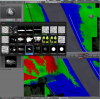
The short story is that I used ksMultilayer_fresnel_nm. But instead of using the txDiffuse to assign color (such as I did for asphalt) it's just a neutral texture (see image below). So you get the true color of RGB channel texture assigned according to txMask that show. I used 4K texture for each Mask. There's 8 of them to cover the entire track, to get fine details such as small grass patch.

The long story:
First (in Blender) I merged all my ground terrain up to the track edge in one object. I then assigned different areas with its own "RGB_LAND_XX" material. Then for each section I had a pure green 4K image to assign.
Then unwrapped each section(smart UV unwrap).

At that point you can export and test with a basic grass texture on the G channel to get things going. You do need the grass texture in DXT5 dds with alpha channel almost pitch black everywhere to get correct results.

The magic happens when you get into texture painting in Blender. You do need to install some brush. I had to make my own based on black and white images found on the web.
Once you have that setup properly you can start painting with red and blue depending on which material you want. I simply followed the aerial photo for the roads with a round brush, but used splatter brushes for the details near the edges of the track.
*** big reminder *** do not forget to save the image (Blender doesn't save it automatically...at least in 2.79).

The big illumination for me came when I realized that ksEditor seamlessly mapped the same texture accross different sections (that have different material - if you have fresnel shader for all section), this is so powerful!
Another thing is that with darker blue or red mask you can almost have another material (say very dark sand looks like soil, just by going darker on the blue channel). This can free a slot for another texture to add in the mix.
Note that in-between color (RGB mixing of textures) generaly don't look great, most pixels on the RGB Mask should be mostly saturated with one color (R, G or B), meaning relatively sharp brushes should be used.

Note: When you combine that with the CSP Grass FX, it's a huge time saver because you'll have fancy grass closly following where the ground is green (not bothering with classic 3D grass after that). Tweaking config file is recommended to get best results.

For the final touch, I post-process the Mask image made in Blender into my image editor to add an extra layer of variation with a black & white variation texture (set to multiply) to create darker and lighter spots (has to be done on all RGB mask textures to get exposure consitent across all the track.

upload_2020-3-17_22-0-45.png
upload_2020-3-17_22-1-23.png
upload_2020-3-17_22-2-56.png


TxDiffuse (64x64 pixels)
upload_2020-3-17_22-15-3.png


upload_2020-3-17_22-55-3.png


A post-processed 4K mask texture
upload_2020-3-17_23-7-57.png
 

Attachments

Last edited:

Norseman

New Member
OK, I will resist that inevitable question that all of us want to know, because I'm dying to get my hands on this track, so rather than ask it, let me instead ask what we can do to contribute to your superb effort Patrice in the way of donations. Please PM and let me know how I can Paypal you some money, because I want to make a donation just to show my appreciation.
 

Patrice COte

Active Member
I know, it must be a long wait!!! Drives me crazy when I see a track being developped that I badly want to drive.

I decided early-on not to release in-work versions. I wanted to go with a high standard release the very first day. That day is getting closer, the list is shrinking. I don't post often but work never stops.
@Norseman I'll send you a PM.

Breaking news!! The provincial gov finally released the 2018 LIDAR scan!!!!!!! It will be useful to validate certain key points around the track (height especially). I'm not doing a full rebuild because the 1999-2001 overhaul did change quite a bit of stuff. So the aerial photo is still my main reference. Lidar validation should not slow me down too much, hopefully.
I had to buy many lidar tiles (@ 12$ each... + tax), which gets me a *little* upset (being polite here) when I see the entire US and many EU scans are free. Costed me already way more than AC itself in early access!!!!
Anyhow, the modern version would (will?) be a lot faster to make after I finish the 60's one with such high quality data available, at last.
 

Johnr777

Moderator
I know, it must be a long wait!!! Drives me crazy when I see a track being developped that I badly want to drive.

I decided early-on not to release in-work versions. I wanted to go with a high standard release the very first day. That day is getting closer, the list is shrinking. I don't post often but work never stops.
@Norseman I'll send you a PM.

Breaking news!! The provincial gov finally released the 2018 LIDAR scan!!!!!!! It will be useful to validate certain key points around the track (height especially). I'm not doing a full rebuild because the 1999-2001 overhaul did change quite a bit of stuff. So the aerial photo is still my main reference. Lidar validation should not slow me down too much, hopefully.
I had to buy many lidar tiles (@ 12$ each... + tax), which gets me a *little* upset (being polite here) when I see the entire US and many EU scans are free. Costed me already way more than AC itself in early access!!!!
Anyhow, the modern version would (will?) be a lot faster to make after I finish the 60's one with such high quality data available, at last.
Dont know why you had to pay, should be freely available through https://www.foretouverte.gouv.qc.ca/

When you get to this screen, it will take you right to the FTP with the tiles to download....

Untitled-1.png
 

Patrice COte

Active Member
Yes I know that site, it looks like you get acess to lidar data. But you don't.... Its processed data (basically images), not the .laz (or .las) file. I downloaded everything from that site (FTP) and it's not the data I'm looking for. Maybe I missed something, could be! But I'm pretty sure it does not cut it to make a really accurate track.
The real data is here (in french)
http://geoboutique.mern.gouv.qc.ca/edel/pages/recherche/critereRechercheEdel.faces

Plenty of good stuff there (but web interface is really bad), Trois-Rivières is there and all the other local tracks. Shame you have to get your wallet out to get them. Only Circuit Gilles-Villeneuve is free on the City of Montreal public lidar database.

This is the paid data in Cloud Compare.
Capture.PNG
 
Last edited:

Johnr777

Moderator
TIF format is just a way they packaged the data, can be opened with Global Mapper and then exported to LAS to bring into cloud compare.
Free stuff isnt bad at all, definitely useful:
Untitled-1.png


But yeah, that is some detailed data you got there :nerd:
 
Top