• Dear visitors,

    The email issue has been finally solved.
    Thank you for your patience and happy browsing.

    Team ACM.
Resource icon

RELEASED-wip Motorpark, Romania 0.4.0

No permission to download

luchian

Administrator
Staff member
..and with this thread, I also inaugurate a new prefix type available on the forum: REQUEST :nerd:. It can be used in almost all sections, to make requests for specific assets or mods.

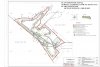
Having said that, @Pixelchaser : would you have little time to extract just the base layout (surrounding area + road) in RTB for Motorpark racing track, please ?

It's basically flat, but would be curious if RTB could see any small level difference. I will then import it into Blender and take care of the physics layer, kerbs and _some_ assets. This is not going to be an "exemplary" project; it's mostly a quick-ish done job, for a friend that goes there every month and would like some practice in-between sessions.

Problem is that google maps is very old (the track was in constructions apparently, so maybe a few years old). Anyway, if you have time (it's not urgent), just have a look please, and see what you could obtain. If possible.

Google link: https://goo.gl/maps/gnXjUc7HZhw

Thank you.

PS: here's a video
 
Last edited:

Pixelchaser

Well-Known Member
ill have a look, flat tracks are best being spotted from pictures or videos. its likely rtb puts height in when its not there. also there isn't decent google imagery for this area, but roughly, you can get the layout. ill stick a road in and make a basic complete layout.
 

luchian

Administrator
Staff member
Thank you very much Ali, really appreciate it. I'll take it from here, and see what will endup with.
I'll get you an ebeer. :)
 

Pixelchaser

Well-Known Member
needs much better layout to follow. should have blown the background up and painted the track then aligned it.
 

luchian

Administrator
Staff member
Yup, it turns out the layout is waaay too hilly :D. IRL is basically flat except for 2-3 curves where there is a slight camber. Will try to flatten all out in Blender and then do a bit of camber manually.
 

luchian

Administrator
Staff member
Pix, what unit do you think RTB exports in (to fbx, that is) ?
(it'll save me making a bunch of tests to see which one is right :D)
 

Pixelchaser

Well-Known Member
it exports in cm`s , In max I keep the scale at 1 so its importing in cm`s and I export in metres and it works that way....
 

luchian

Administrator
Staff member
Yes, it seems that way. I've done some testings and got to see that *100 gives the closest size.
In the mean time, I got to find also a layout drawing of the track.. and they don't match, of course.. :ninja:
So now I am wondering, is there maybe a deviation from google, or the plan is an early iteration and they didn't really respect it ? :D

Anyway, I think I'm gonna go with the plan though.

2017-08-20_230132.jpg
 

luchian

Administrator
Staff member
Yeah, the image is maybe not the best, I did it before playing with scale all the way. In any case, I end-up with some deviations from the plan. So, I'll probably go with the plan instead of just relying on google maps.

dilema.jpg
 

Pixelchaser

Well-Known Member
google is always out by 10-20 metres side to side. and its the lowest quality google image ive ever used. but the plan there isn't what was built either. the joining road that halfs the track config isn't there as they built it.
 

luchian

Administrator
Staff member
Hey people,

A Blender question now (oooh, I have a lot ! :D):
Any tool to measure the actual length of a bezier curve in Blender ? @LilSKi maybe ? :D

EDIT: found a little script that does just that. To use it, just drop it the text editor and with the bezier selected, hit run script.
 

Attachments

Last edited:

luchian

Administrator
Staff member
Turns out you are right Ali. The google maps version is way closer to reality:
Your google version: track length is 4028 m (instead of 4129 m real)
My scaled to plan version is barely 3800 m.
 

Pixelchaser

Well-Known Member
you mean the plan drawing isn't the correct plan ? well my corners are wack though, give me the plan and ill re doo it, save you plenty time in blender, tbh moving all those poly around is pointless.
 

luchian

Administrator
Staff member
Here's the plan, but I really think it's not what they finally did.. Although you have all date, like radius and stuff, if you work at scale (I have used some blocks they have with dimensions) you will end-up with a smaller track.
 

Attachments

LilSKi

Well-Known Member
Take a road object that is the length of your track in a straight line and subdivide it a bunch length ways. Assign it the curve and if the ends butt up to each other the scale is correct.
 

Pixelchaser

Well-Known Member
I think that weird curved intersection was omitted from the design, anway I till help get the turn radius more uniform as it is in the design,
 

luchian

Administrator
Staff member
Well, that's the thing. Some of them might be more "off" on the plan, than on google maps version.
Here is an example of the map they hand you when doing the briefing (which we could assume it's more up-to-date).
IMG_1068_1.jpg


As you can see, turn 9 it's closer to your version than the rounded smooth one on the plan..
 

Pixelchaser

Well-Known Member
bing maps actually has a better version of the scenery, brighter more defined lines, originally i just layed the track on the google image, what ill do tomorrow is scale it all up uniformly and create a sharp track line to work with in rtb from sharp Bezier paths in photoshop that will recreate a proper track outline to work with and be able to get the radius smooth and correct.
 
Top